Overview
Nestled in the eastern Himalayas, Bhutan, often referred to as the “Land of the Thunder Dragon,” is a paradise for trekkers and nature enthusiasts. This enchanting kingdom, with its pristine landscapes, rich cultural heritage, and commitment to environmental conservation, offers an unparalleled trekking experience that combines natural beauty with spiritual serenity.
Unique Trekking Experience
Bhutan’s trekking routes traverse through some of the most unspoiled and remote landscapes in the world. The trails lead adventurers through dense forests, alpine meadows, and along ancient paths that have been used by Bhutanese for centuries. The dramatic variation in altitude, from subtropical plains to lofty mountain passes, provides trekkers with a diverse array of ecosystems and breathtaking vistas.
Cultural Immersion
Trekking in Bhutan is not just about the physical journey; it’s a cultural immersion. The trails often pass through traditional Bhutanese villages where life has changed little over the centuries. Trekkers have the opportunity to interact with local people, visit ancient monasteries, and experience the deeply ingrained Buddhist culture that permeates every aspect of Bhutanese life.
Environmental Stewardship
Bhutan’s commitment to preserving its natural environment is evident in its strict conservation policies. The country has set aside more than 50% of its land as protected areas and forest reserves. Bhutan’s trekking routes are designed to minimize environmental impact, ensuring that the pristine nature and biodiversity are preserved for future generations.
Some of the Highlights - Trekking in Bhutan
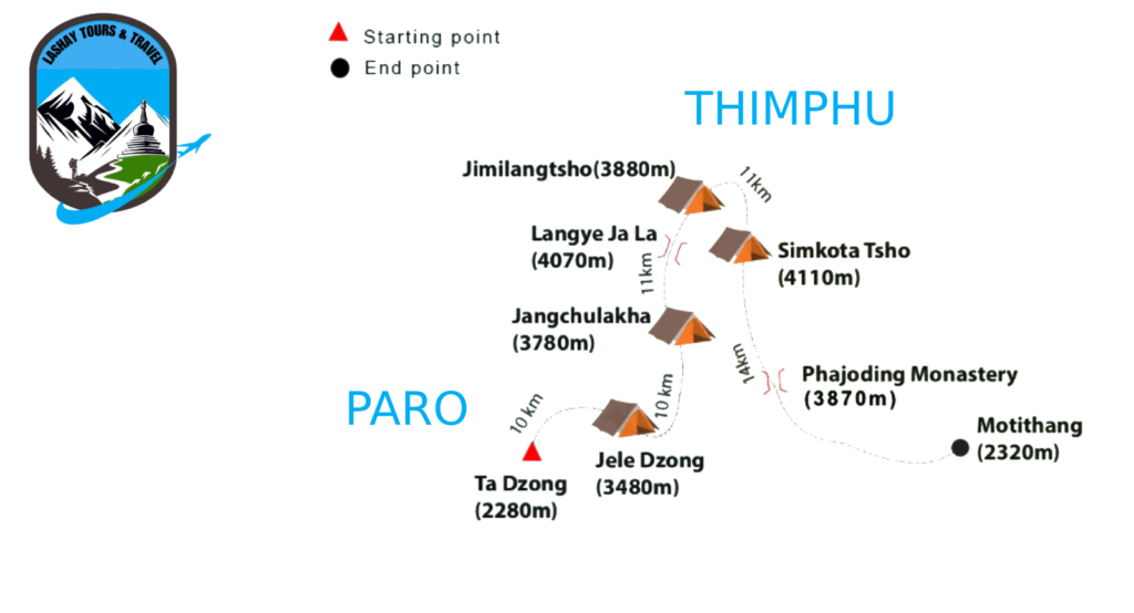
The Druk Path Trek is one of Bhutan’s most popular and scenic trekking routes, offering stunning views of the Himalayan landscape, pristine lakes, and lush forests. This trek typically takes around five to six days to complete, covering a distance of approximately 50 miles (80 kilometers) from Paro to Thimphu, the capital city of Bhutan.
Day 1: Paro to Jele Dzong
- Start your trek from the Paro Valley, passing through terraced fields and scattered hamlets.
- Ascend gradually through pine forests to reach Jele Dzong, an ancient fortress located at an altitude of about 3,400 meters.
- Overnight stay at a campsite near Jele Dzong.
Day 2: Jele Dzong to Jangchulakha
- Begin the day with a steep climb to Jangchulakha, crossing through alpine meadows and rhododendron forests.
- Along the way, enjoy breathtaking views of Mount Jumolhari and other snow-capped peaks.
- Camp overnight at Jangchulakha, situated at an altitude of around 3,700 meters.
Day 3: Jangchulakha to Jimilangtso
- Continue trekking through dwarf rhododendron trees and yak herder’s camps.
- Ascend to a ridge offering panoramic views of the surrounding mountains and valleys.
- Descend to Jimilangtso, a beautiful lake known for its crystal-clear waters.
- Camp near the lakeshore and enjoy the serene ambiance.
Day 4: Jimilangtso to Simkota
- Embark on a scenic trek alongside two more lakes, Janetsho and Sakkatsho.
- Traverse through yak herder’s camps and across several small streams.
- Ascend to Simkota Pass (4,200 meters) for stunning views of Mount Gangkar Puensum and other peaks.
- Camp overnight at Simkota, located at an altitude of around 4,110 meters.
Day 5: Simkota to Phajoding
- Trek downhill through juniper forests and rhododendron bushes.
- Pass by Phume La Pass (4,210 meters) before descending to Phajoding Monastery.
- Explore the monastery and enjoy panoramic views of Thimphu Valley.
- Camp overnight near Phajoding.
Day 6: Phajoding to Thimphu
- Conclude your trek with a descent to Thimphu, the capital city of Bhutan.
- Descend through blue pine forests and past prayer flags fluttering in the breeze.
- Arrive in Thimphu, where you can explore the city’s cultural attractions and vibrant markets.
This route map provides a simplified overview of the Druk Path Trek:
Paro — Jele Dzong — Jangchulakha — Jimilangtso — Simkota — Phajoding – Thimphu
Drukpath Trek Route Map
Overview
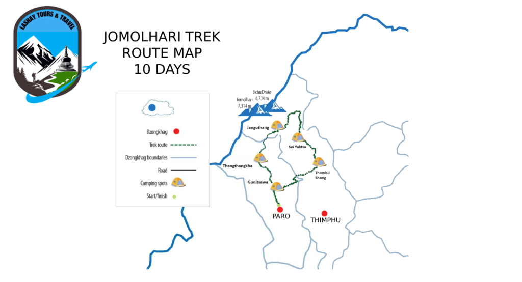
The Jomolhari Base Camp Trek is one of the most popular and rewarding treks in Bhutan, offering stunning views of snow-capped peaks, lush valleys, and diverse flora and fauna. This trek takes you to the base camp of Mount Jomolhari (7,326 meters), the second highest peak in Bhutan, revered as the abode of a protective goddess. The journey combines challenging high-altitude trekking with cultural experiences in remote villages, providing an unforgettable adventure.
Trek Highlights
- Mount Jomolhari: Majestic views of one of Bhutan’s most sacred mountains.
- Diverse Landscapes: Trek through pristine forests, alpine meadows, and glacial valleys.
- Remote Villages: Experience the traditional lifestyle of Bhutanese highlanders.
- Wildlife: Spot rare animals such as blue sheep, Himalayan takin, and various bird species.
Detailed Itinerary
Day 1: Arrival in Paro
- Morning: Arrive at Paro International Airport, where you will be warmly greeted by your guide.
- Afternoon: Transfer to your hotel and explore Paro town. Visit the National Museum of Bhutan and Paro Rinpung Dzong.
- Evening: Prepare for the trek with a briefing and gear check.
- Accommodation: Hotel in Paro.
Day 2: Paro to Shana (Start of Trek)
- Morning: Drive to the trek starting point at Drukgyel Dzong (2,580 meters).
- Afternoon: Trek through fields and forests to Shana (2,870 meters).
- Evening: Camp overnight by the river.
- Trek Distance: 17 km | Trek Time: 5-6 hours.
Day 3: Shana to Soi Thangthangkha
- Morning: Continue trekking along the river, ascending through a rhododendron forest.
- Afternoon: Reach the campsite at Soi Thangthangkha (3,750 meters), with views of Mount Jomolhari in the distance.
- Evening: Camp overnight.
- Trek Distance: 22 km | Trek Time: 7-8 hours.
Day 4: Soi Thangthangkha to Jangothang
- Morning: Trek through yak pastures and juniper forests, with increasing views of Mount Jomolhari.
- Afternoon: Arrive at Jangothang (4,080 meters), the base camp for Mount Jomolhari, offering spectacular mountain vistas.
- Evening: Camp overnight.
- Trek Distance: 19 km | Trek Time: 5-6 hours.
Day 5: Acclimatization Day at Jangothang
- Morning: Enjoy a rest day to acclimatize. Optional hikes to Jomolhari Glacier or Tshophu Lakes.
- Afternoon: Explore the surrounding area and visit local yak herder camps.
- Evening: Camp overnight.
- Trek Distance: Variable depending on day hikes.
Day 6: Jangothang to Soi Yaksa
- Morning: Ascend to the Nyile La Pass (4,890 meters) with panoramic views of the Himalayas.
- Afternoon: Descend to Soi Yaksa (3,800 meters), passing through beautiful meadows.
- Evening: Camp overnight.
- Trek Distance: 16 km | Trek Time: 6-7 hours.
Day 7: Soi Yaksa to Thombu Shong
- Morning: Trek through scenic landscapes and cross several streams.
- Afternoon: Reach Thombu Shong (4,180 meters), a picturesque campsite.
- Evening: Camp overnight.
- Trek Distance: 12 km | Trek Time: 5-6 hours.
Day 8: Thombu Shong to Gunitsawa Village and Return to Paro
- Morning: Climb to Thombu La Pass (4,380 meters) and enjoy the views before descending.
- Afternoon: Reach Gunitsawa Village (2,730 meters) and end the trek. Drive back to Paro.
- Evening: Check into your hotel and enjoy a well-deserved rest.
- Trek Distance: 13 km | Trek Time: 5-6 hours.
Day 9: Departure from Paro
- Morning: Transfer to Paro International Airport for your departure flight, carrying with you unforgettable memories of the Jomolhari Base Camp Trek.
Jhomolhari Trek Route Map
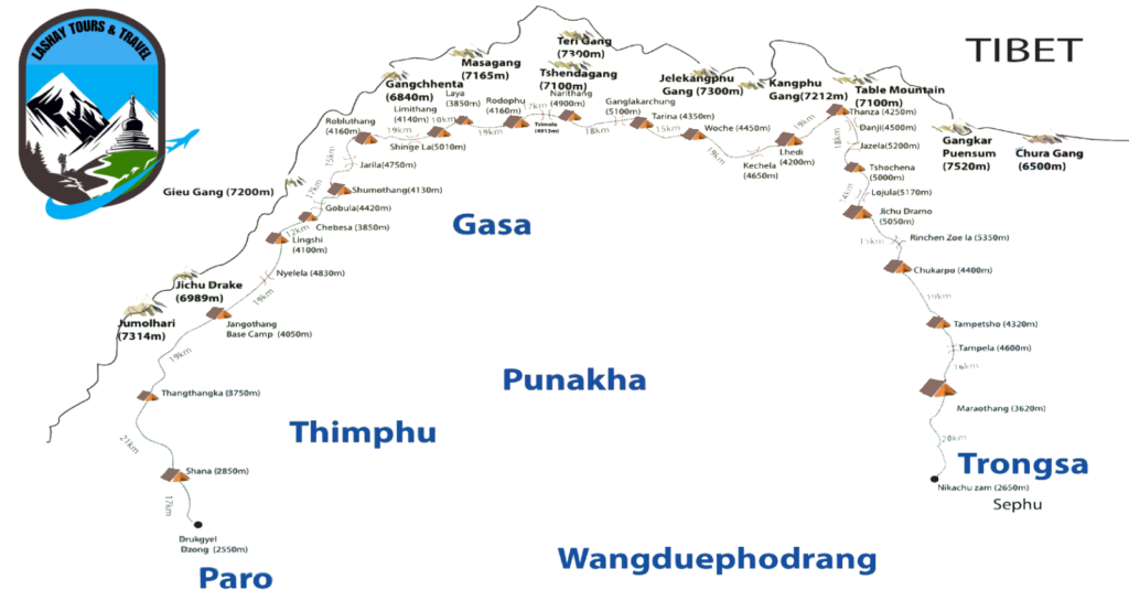
The Snowman Trek is one of the most challenging and rewarding high-altitude treks in the world, located in Bhutan. This trek is known for its stunning natural beauty, remote trails, and the cultural richness it offers to adventurers. Here’s an overview of what makes the Snowman Trek special:
Overview
- Location: The Snowman Trek traverses the remote and rugged regions of Bhutan, a small Himalayan kingdom nestled between China and India.
- Distance: Approximately 200 miles (322 kilometers).
- Duration: Typically takes about 25 to 30 days to complete.
- Elevation: Trekkers reach altitudes as high as 18,480 feet (5,630 meters) and cross several high mountain passes.
- Best Time to Trek: Late September to mid-November when the weather is relatively stable, and the skies are clear.
Route and Highlights
- Starting Point: The trek usually starts from Paro, a town known for its historical sites and the famous Tiger’s Nest Monastery.
- Ending Point: The traditional endpoint is in the remote region of Bumthang, though variations of the trek can end in different locations.
- Mountain Passes: Trekkers cross several high passes, including the Rinchenzoe La, Loju La, and the highest pass, Gangla Karchung La.
- Scenery: The trek offers breathtaking views of the Himalayas, including peaks such as Jomolhari, Jichu Drake, and the awe-inspiring Gangkar Puensum, the highest unclimbed peak in the world.
- Flora and Fauna: The trail passes through diverse ecosystems, from lush forests to alpine meadows, home to a variety of wildlife including the elusive snow leopard, blue sheep, and various bird species.
Cultural Experience
- Villages and Monasteries: The trek passes through remote villages and ancient monasteries, allowing trekkers to experience Bhutanese culture and hospitality firsthand.
- Festivals: Depending on the timing, trekkers might witness local festivals, which are vibrant displays of Bhutanese traditions, dances, and music.
Challenges
- Altitude: The high elevations pose a risk of altitude sickness, making acclimatization crucial.
- Terrain: The trail includes steep ascents and descents, river crossings, and potential snow and ice, requiring good physical fitness and trekking experience.
- Weather: Conditions can be unpredictable, with the possibility of snowstorms even during the recommended trekking season.
Preparation
- Permits: Trekkers need to arrange permits through a licensed Bhutanese tour operator as independent travel is not allowed in Bhutan.
- Guides and Support: The trek requires support from experienced guides, porters, and pack animals to carry supplies.
- Gear: Proper high-altitude trekking gear is essential, including warm clothing, a sturdy tent, sleeping bags rated for cold temperatures, and reliable trekking boots.
Significance
The Snowman Trek is more than just a physical challenge; it is a journey through one of the most unspoiled and serene landscapes on Earth. The combination of natural beauty, cultural immersion, and the sense of accomplishment from completing such a demanding trek makes it a dream adventure for many avid trekkers.
Snowman Trek Route Map
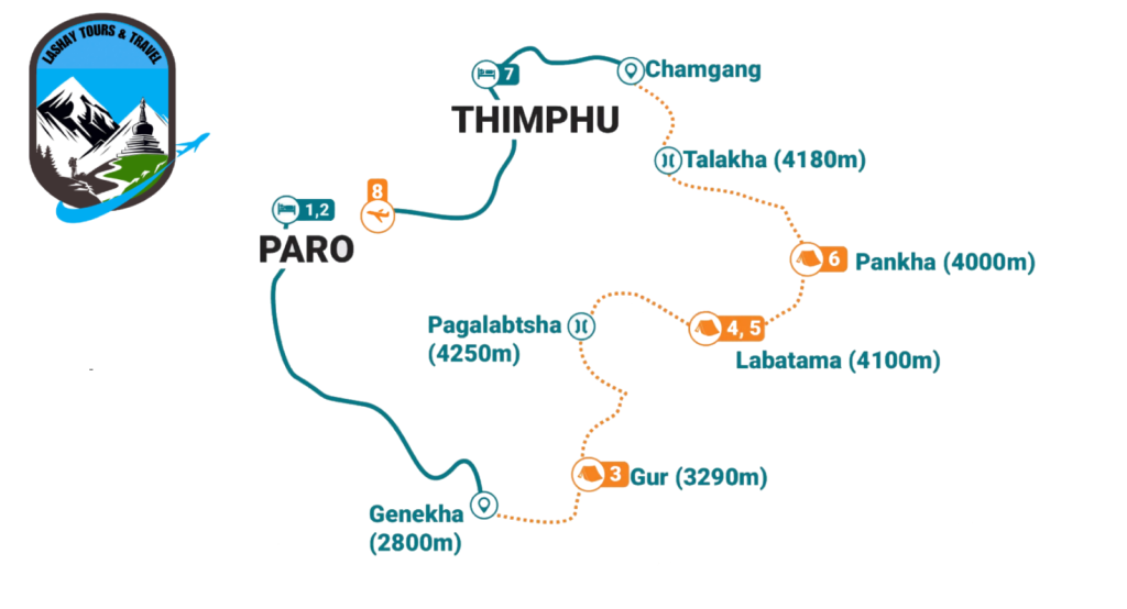
The Dagala 1000 Lakes Trek is a captivating and less-traveled trekking route in Bhutan, offering an extraordinary experience for hikers who seek solitude and breathtaking natural beauty. Known for its numerous pristine high-altitude lakes, the trek provides a serene and picturesque landscape, making it a unique adventure.
Overview
- Location: The trek is located in the Thimphu and Paro districts of Bhutan.
- Duration: Typically, the trek spans over six days.
- Difficulty: Moderate to challenging, depending on the weather and trail conditions.
- Altitude: The trek reaches a maximum altitude of around 4,520 meters (14,830 feet).
Highlights
- Scenic Lakes: As the name suggests, the trek takes you through a region dotted with numerous alpine lakes, each with its own unique charm and crystal-clear waters.
- Panoramic Views: The trail offers stunning views of some of the highest peaks in the Himalayas, including Mount Everest, Mount Kanchenjunga, and Bhutan’s own Jomolhari.
- Rich Biodiversity: The route passes through lush rhododendron forests, alpine meadows, and diverse flora and fauna. It is common to spot blue sheep, Himalayan monal, and various other wildlife.
- Cultural Experience: The trek includes visits to remote Bhutanese villages, providing a glimpse into the traditional lifestyle and culture of the local people.
- Isolation and Tranquility: The Dagala 1000 Lakes Trek is less frequented by tourists, offering a peaceful and undisturbed trekking experience.
Trekking Itinerary
Day 1: Thimphu to Gynekha
- Drive from Thimphu to Gynekha.
- Trek starts with a descent to the river followed by an ascent to a large meadow.
Day 2: Gynekha to Gur
- A gradual climb through terraced fields and coniferous forests.
- Camp at Gur, surrounded by wildflowers and meadows.
Day 3: Gur to Labatama
- Continue climbing to the highest point of the trek.
- Descend to Labatama, a beautiful campsite by a lake.
Day 4: Labatama Exploration
- A rest day to explore the nearby lakes.
- Opportunity for fishing or simply enjoying the scenic beauty.
Day 5: Labatama to Panka
- Trek through several passes with panoramic views.
- Camp at Panka amidst a stunning backdrop.
Day 6: Panka to Talakha and Drive to Thimphu
- A descent through alpine meadows and forests.
- Visit Talakha Monastery before descending to Chamgang.
- Drive back to Thimphu.
Best Time to Trek
The best time to undertake the Dagala 1000 Lakes Trek is during the spring (April to June) and autumn (September to November). During these periods, the weather is stable, and the skies are clear, offering the best views and comfortable trekking conditions.
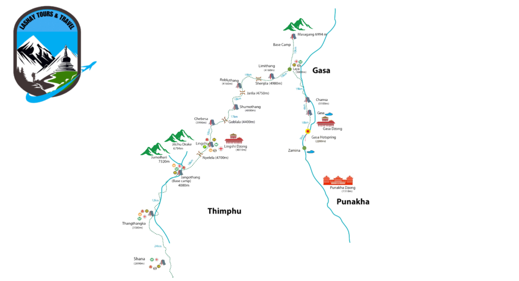
The Laya Gasa Trek is one of Bhutan’s most renowned and picturesque trekking routes, offering a captivating journey through the high Himalayas. This trek is celebrated for its stunning landscapes, diverse flora and fauna, and encounters with remote villages inhabited by the Layap people, known for their unique culture and traditions.
Overview
- Location: The trek takes place in the northwestern region of Bhutan, starting from Paro or Punakha and ending in Gasa or Punakha.
- Duration: Typically spans from 12 to 14 days, depending on the specific itinerary and pace.
- Difficulty: Moderately challenging to strenuous, due to high altitude passes and variable weather conditions.
- Altitude: The trek reaches altitudes above 4,000 meters (13,000 feet), with the highest point being the Laya Pass at around 4,100 meters (13,500 feet).
Highlights
-
Scenic Beauty: The trek offers breathtaking views of snow-capped peaks including Mount Jomolhari and Jichu Drake, pristine glacial lakes, and verdant valleys.
-
Cultural Immersion: Encounter traditional villages such as Laya, known for its distinctive customs like the Layap dress, unique language, and hospitality of the inhabitants.
-
Flora and Fauna: Traverse through diverse ecosystems ranging from dense forests of rhododendron, oak, and pine to alpine meadows where yaks graze. Spot wildlife like blue sheep, takin (Bhutan’s national animal), and various bird species.
-
Hot Springs: Relax tired muscles at the natural hot springs near Gasa Dzong, offering a soothing respite amidst the rugged terrain.
-
Bhutanese Hospitality: Experience warm hospitality in campsites and guesthouses managed by local communities, offering insights into Bhutanese lifestyle and cuisine.
Trekking Itinerary
Day 1-2: Paro to Shana and Thangthangkha
- Begin with a drive to Shana and start trekking along the Paro River, passing through forests and meadows to reach Thangthangkha.
Day 3-4: Thangthangkha to Jangothang
- Trek through pristine landscapes with views of Mount Jomolhari, eventually reaching Jangothang, a scenic base camp beneath the mountain.
Day 5-6: Jangothang to Lingshi
- Cross the first mountain pass, Nyile La (4,890m), and descend to Lingshi, passing by yak herder camps and enjoying panoramic mountain views.
Day 7-8: Lingshi to Chebisa and Shomuthang
- Trek through rhododendron forests and yak pastures to reach Chebisa, a picturesque village. Continue to Shomuthang, crossing the second pass, Yale La (4,950m).
Day 9-10: Shomuthang to Robluthang and Limithang
- Ascend to Jare La Pass (4,785m), offering stunning views of Bhutan’s highest peaks. Descend to Robluthang and continue to Limithang, a high-altitude campsite.
Day 11-12: Limithang to Laya and Gasa Hot Springs
- Trek through remote valleys to reach Laya village, known for its unique culture. Continue to Gasa, where you can relax in natural hot springs.
Laya-Gasa Trek Route Map
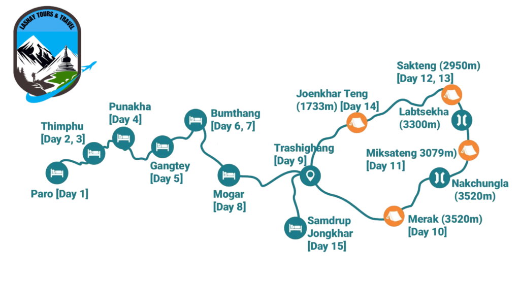
The Merak-Sakteng Trek is a fascinating and unique trekking experience in Bhutan, offering a journey through the remote and culturally distinct regions of Merak and Sakteng. This trek is notable for its opportunity to interact with the semi-nomadic Brokpa people, who have preserved their traditional way of life.
Overview
- Location: Eastern Bhutan, Trashigang District
- Duration: 7-8 days
- Difficulty: Moderate to Challenging
- Best Time to Trek: March to May and September to November
Highlights
- Cultural Immersion: The trek provides a rare chance to experience the culture, traditions, and lifestyle of the Brokpa people, known for their unique customs and attire.
- Scenic Beauty: Trekkers will traverse diverse landscapes, including lush forests, alpine meadows, and high mountain passes with stunning views of the eastern Himalayas.
- Wildlife: The Sakteng Wildlife Sanctuary, which the trek passes through, is home to various wildlife species, including red pandas, Himalayan black bears, and several bird species.
- Traditional Villages: Visit remote villages where traditional practices and beliefs are still maintained, offering a glimpse into an unspoiled way of life.
Detailed Itinerary
Day 1: Trashigang to Chaling to Damnongchu
- Distance: Approximately 12 km
- Highlights: Drive from Trashigang to Chaling and begin the trek to Damnongchu. The trail ascends gradually through beautiful forested areas.
Day 2: Damnongchu to Merak
- Distance: Approximately 14 km
- Highlights: Trek to Merak, a Brokpa village. Enjoy cultural interactions and explore the unique traditions and lifestyle of the Brokpa people.
Day 3: Merak to Miksa Teng
- Distance: Approximately 16 km
- Highlights: A challenging day involving a climb to the high pass of Nachungla at 4,150 meters, followed by a descent to Miksa Teng.
Day 4: Miksa Teng to Sakteng
- Distance: Approximately 13 km
- Highlights: Trek through diverse landscapes to reach Sakteng, another Brokpa village. Experience the rich culture and traditional way of life.
Day 5: Rest Day in Sakteng
- Highlights: Spend a day in Sakteng to explore the village, interact with locals, and enjoy the scenic beauty.
Day 6: Sakteng to Jyonkhar Teng
- Distance: Approximately 17 km
- Highlights: A long trekking day descending to Jyonkhar Teng through dense forests and across streams.
Day 7: Jyonkhar Teng to Phongmey to Trashigang
- Distance: Approximately 12 km
- Highlights: Trek to Phongmey, where a vehicle will be waiting to transfer you back to Trashigang.
Preparation Tips
- Physical Fitness: This trek requires good physical conditioning due to its length and the elevation gain. Regular training and cardiovascular exercises are recommended.
- Altitude Acclimatization: Spend a few days at higher altitudes before the trek to acclimatize.
- Gear: Essential trekking gear includes sturdy hiking boots, warm clothing, rain gear, a sleeping bag, and a tent.
- Permits: Ensure you have the necessary trekking permits, which are typically arranged by the tour operator.
Conclusion
The Merak-Sakteng Trek is an extraordinary journey through one of Bhutan’s most culturally rich and unspoiled regions. It offers trekkers the opportunity to experience the unique lifestyle of the Brokpa people while enjoying the natural beauty and biodiversity of eastern Bhutan. Suitable for experienced trekkers looking for a culturally immersive adventure, this trek is both challenging and rewarding.
